
Smart Map – Save Time and Do More Deals


A few months ago I had a realization which led me down the path that would ultimately result in development of our new website, Smart Map. The realization was that land development professionals really struggle with the mapping side of what they do.
No matter what space you occupy in the development industry, you can probably think back to a time recently when someone sent you a map of a property that was one of the following:
- a map from an old appraisal
- a years old map from a previous listing brochure
- an assessor parcel map that had been marked up in Photoshop (or worse, Microsoft paint… or worse, with a red marker)
- or maybe any of the above options would have been an improvement because all you had to work with was an assessor parcel number
It’s worth mentioning that the year is 2016. You can order a taxi by pressing a button on your phone. Meanwhile, we’re using sharpies to draw on black and white assessor maps.
But things don’t have to be that difficult. Lots of the data we need for real estate development is produced by cities and counties, and there are also new open source web mapping libraries.
We took advantage of these realities and built an online interface that allows easy mapping of any property in Los Angeles, Riverside, San Bernardino, and Kern counties in California. It’s actually somewhat trivial to add more counties, so we’ll probably slowly add geographic areas over time.
So what is Smart Map and what can you do with it? Here are a few sample use cases:
- Search for an APN, select that parcel, and get a unique url to send to a colleague.
- Get ownership information for any parcel
- Add some comments to your map
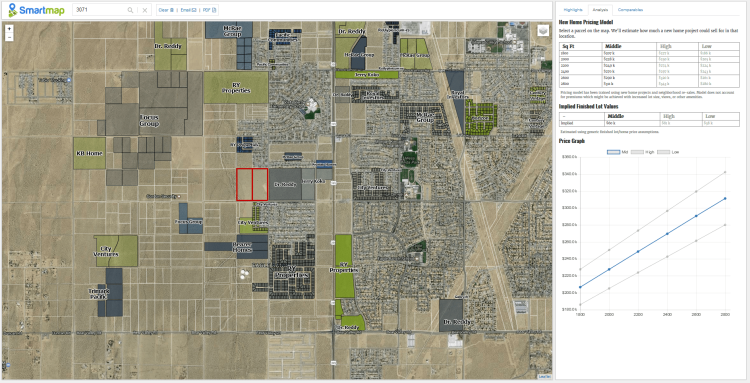
- Estimate home pricing for a new residential development
- Get a pro forma estimate for a finished lot value
- View prices for nearby actively selling subdivisions
- Get a list of possible land comparables
You can do all of the above and generate a unique link that can be easily emailed.
I personally have a desktop GIS system which has the features listed above, along with more capabilities. But I’ve essentially abandoned that system now that I can use Smart Map. The sheer speed of using Smart Map means that I can often accomplish my mapping activities in a fraction of the time. Also, when I send a link to my map, the recipient isn’t getting just a static PDF that I’ve generated. They’re getting a dynamic map that has actual functionality. If I send a map of a property, the recipient can easily click on the map to see who owns the adjoining property (for example). Or they can check pro forma pricing for finished lots.
We’re probably biased, but we also think the name Smart Map is accurate. It really will let you perform analytics which otherwise take a not inconsequential amount of time. For instance, think about the amount of time you might devote to the problem of estimating what a new subdivision could sell for on any potential development. Maybe you would enlist the help of a consultant, who would take days to weeks and thousands of dollars, to generate an estimate that they don’t have to stand behind. Or maybe you would do your own market analysis and check nearby subdivisions, along with re-sale prices. Smart Map reduces either of those actions to the click of a button. You can get in the ballpark in almost no time. Smart Map also has a comparables engine which is currently pretty good and which we’re also constantly improving to make better.
We think there are a lot of things that we can build on top of Smart Map that could be really exciting. Some of those features will be internal to our company, but we think Smart Map is a great tool to release to the broader land development community to make all of our lives just a little bit easier. Whether you are the offending sender of poorly Photoshopped maps, or the recipient of awful sharpie created maps, you should want everyone to have Smart Map available for fast web mapping of development sites.
